fbpx

Understanding the Impact of Drone Data Analytics In Agriculture

Using drone-acquired data for analytics in agriculture has several significant benefits to the industry. The challenge is that many farmers and agriculturalists see drones as an additional expense and a source of unstructured data they don’t know how to act on.

At Aerial Vantage, we understand that the agricultural industry is looking for ways to gain a return on investment through using drones. In fact, in a recent survey conducted by DroneDeploy, 56% of respondents said they view interpreting drone data to make crop decisions as the challenge they most want to address.

The data science field is ripe with innovation, and Aerial Vantage has made sure to capitalize on the use of technologies like artificial intelligence and machine learning for use in our drone services to help the agriculture industry get easy access to valuable, actionable information.

We’re tackling this head-on with powerful analytic capabilities that enable swift and thorough processing of aerial drone data. Having this information accessible and readily available can make managing agricultural lands more efficient, saving time and money. Let’s dive into how data science can benefit your organization.

Collecting Imagery Data

The first step in using drone analytics in agriculture is having the ability to capture relevant information. Our drone geospatial intelligence platform, Accelerate, captures disparate image data and can be programmed to deliver information that is crucial for farm management objectives.

Smart spraying and seeding aren’t the only ways to increase overall agricultural efficiency, cut costs, or increase yields. Drones can also be used to map an area and create new insights — taking the heavy lifting out of much of the growing process. Here are a few examples of how this technology can be applied.

“Drone imagery compensates for the limitations of drive-by scouting,” explains Aerial Vantage agronomist Anna Weigel, who specializes in crop and soil science. “Where previously you only had time to walk a few rows into your fields or check on things from the driver’s seat of your pickup, with aerial imagery it is now practical to evaluate the health of your entire field, and employ targeted scouting to diagnose crop quality concerns.”

farm field Drone Data Analytics in Agriculture

Before Planting

There is a lot of preparation involved in the time leading up to planting season. During this period, growers can rely on ag analytics from drones, which deliver important insights such as:

  • Assessing water conditions in fields
  • Determining drainage management needs
  • Tracking soil erosion between crops


Throughout the Growing Season

As crops begin to grow, this season represents a pivotal time for agriculturalists. You need to ensure plants are developing at a healthy rate and understand what they need to continue on the path for growth. Drone data analytics in agriculture can provide you with details such as:

  • Detecting plant stress; gauging productivity and plant health
  • Identifying resistant weeds or invasive species
  • Adjusting nitrogen fertilization for row crops
  • Rapidly assessing storm damage to settle claims quickly
  • Optimizing water usage by monitoring drought stress at different growth stages
  • Inventory of plant population, size, and health.
  • Providing guidance for optimal harvest timing and accurately estimating yield
wheat field Drone Data Analytics in Agriculture
cow herd Drone Data Analytics in Agriculture

Livestock and Infrastructure 

Finally, our drone data analytics come in handy for use cases beyond crop management. Indeed, we can deploy custom deep learning models and computer vision technology to provide producers with a 360-degree view of their land, from infrastructure to livestock. This includes:

  • Foraging Conditions: A flyover can show ranchers the pastures with the best grazing conditions. With multiple flyovers, our analysts can help you map efficient grazing moves throughout the year to maintain pasture and forage quality
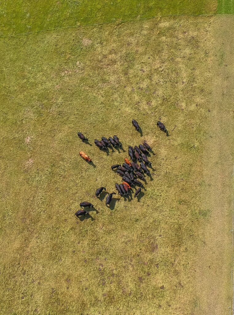
  • Livestock Inventory: Drone data can also help you count your animals and spot newborn animals, relieving much of the stress during calving season. Thermal sensing can detect animal stress, directing ranchers to herds with the highest needs.
  • Infrastructure Assessments: Discover fence damage, roof problems and road degradation before they lead to further losses.
  • Grove and Forest Assessments: Flyovers can quickly count trees, spot diseased and damaged trees, assess canopy cover, and estimate tree age.

“Utilizing drone imagery for livestock monitoring and inventory is a cost effective way to increase accuracy and scope of your management activities while decreasing stress and injury potential of your livestock,” adds Weigel.

Creating Custom Deep Learning Models

Aerial Vantage is committed to staying at the forefront of the latest drone data analytics trends and innovations for our agriculture customers. Our expertise in using artificial intelligence and machine learning allows us to turn captured data into value for your organization, such as implementing computer vision algorithms that consistently provide insights. These models are custom tuned to fit your operation.

Artificial intelligence is a system that automatically ingests & aggregates raw data, transforms this data into insights using machine learning algorithms, recommends optimal actions, and learns from those decisions. AI should aid humans in making decisions, not replace them. Some steps can be automated but understanding what to do with these insights and how the algorithms balance explainability vs. performance is still necessary to reach full AI adoption.

Aerial Vantage relies on computer vision, a subset of AI, to automate drone tasks such as extracting information from aerial images that would normally require human vision. Through machine learning, we train the computer to recognize and analyze objects and events, so that while the drone is in the air, it is delivering information you care about. 

Through a strategic partnership with Mosaic Data Science, a recognized industry leader in custom machine learning & artificial intelligence services, we consistently bring our agriculture customers cutting-edge insights from drone missions. This partnership offers organizations an unparalleled competitive advantage with access to experienced, qualified data scientists that specialize in computer vision.

We handle the technical details of tuning this technology, with collaboration from your agricultural subject matter experts, to deliver massive ROI on your drone investment so you can focus on the strategic and operational decisions critical to your stakeholders.

flying drone with data dashboard

Delivering Actionable Insights

Aerial Vantage carries years of experience collecting and analyzing agriculture intelligence data with cutting edge machine learning and computer vision techniques. We do the heavy lifting of managing your drone mission and collecting the data, then presenting it in a way that is best suited for your organization. 

After a drone mission, you’ll receive a breakdown of our drone data analytics in agriculture via a dashboard or similar presentation format. Here, you will be able to easily access information on topics that you deemed important for growing purposes. 

This data can be updated in real-time and adjusted for different time periods or comparisons. Aerial Vantage presents this data to your liking via our geospatial intelligence platform, Accelerate.

To uncover drone data analytics in agriculture, we build upon our existing agriculture intelligence experience to identify the data, information, and analytics needs of customers like you. Next, we design and deploy custom solutions that facilitate automation and offer you a competitive edge. To learn more about how we can help your agriculture organization grow, contact us today.

© Aerial Vantage 2022 All Rights Reserved. | Accelerate Terms of Service